By Jim T. Ryan, Hooligan-in-Chief
Previously: Josh Stadler and I started (Part 1) an attempt to do one of Pennsylvania’s hardest trails, the 42-mile Black Forest Trail, in three days when the standard trek is four days. It was our second attempt at BFT in six months, the first being a winter hike that ended after just 18 miles. On the first day (Part 2) in June, we forgot our map and only did about 10 trail miles when we wanted to do much more.
Last time (Part 3), we embarked on day two through the “Sea of Ferns.” In this installment, we continue on our second day but find once again that the BFT makes its own plans for those who set foot on its mossy devil’s-tongue path…
The Sea of Ferns on the BFT’s plateau stretches are a treasure of Pennsylvania’s “Black Forest” — so named because the forest was so dense when the logging companies set out to cut it, that daylight rarely reached the underbelly.
With our goal to hit at least 20 miles on Day 2, Josh and I made as much good time on the flat stretches as we could. We knew we’d still have a large descent and ascent somewhere after lunch and we wanted to make camp on a ridge somewhere around mile 12. On Day 1, we stopped at an overlook on Hemlock Mtn. where others had camped before. The prospect of having open sky to peer up at the Milky Way after a hard-day’s hike was alluring.
Foster’s Hollow
The first uphill out of the creek bed was relatively gradual next to the switch-backing of the previous day, but I have a feeling it weighed on Josh. We were slow going and reached Foster’s Hollow about mid-morning. Descending was slow because of my knees.
At the crotch of Foster’s Hollow — a long gash down to one of Slate Run’s tributaries — we stopped briefly to catch our breath, but we figured we were making bad time already. Regularly, we might hike down the hollow to the creek and take in the scenery, but any downhill means you have to come up and that wasn’t looking like a good plan.
On the uphill out of Foster’s Hollow, it became noticeable Josh was lagging behind significantly, and we stopped often. It seemed to never end, but eventually the itch-weed disappeared and we realized we were once again near the plateau rim.
Mid-way up that last stretch, we checked the map. Foster Hollow seems to be an almost unnecessary detour on paper. The trail could have skirted the rim and avoided a knee-taxing descent and ascent that served little purpose.
Then again, I think we were only saying that because we were tired of feeling gravel chips in our knee joints.
The “Knife’s Edge”
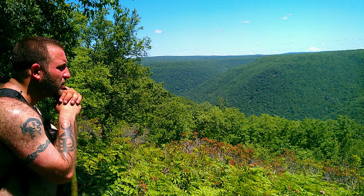 |
| Josh surveys Slate Run gorge, BFT day 2. |
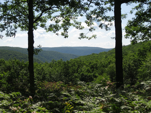
Eventually, the trees and ferns of the BFT gave way to warm sun and a small clearing. But if you weren’t paying attention, you’d likely walk right off a steep mountainside into Slate Run below you. We rested, gazing into the valley below and the steep slopes beyond.
Slate Run is an intriguing view, running for miles up into the plateau.
Turning right on the trail, we began to slope down slightly through the rim forest until the ground got rocky and the underbrush thin. I remember thinking, well, on our way down now.
Over the first slope, the trees thinned more, and the trail followed a nearly naked ridge line sloping down and to the right. But you couldn’t see much more than 30 or 40 feet in front of you. The trail just appeared to drop off the edge and there was maybe 20 feet total on the ridge line before it sloped steeply into the gorge on either side.
“Uh, where the hell is this taking us?” I said.
“Looks like we’re going to walk right off the mountain,” Josh said.
BFT’s “knife edge” at mile 40 is a surreal natural feature because it gives you the feeling that you’re walking on air into Slate Run gorge as the valley is spread out before you. We didn’t say much on that short stretch of trail except an occasional “wow” or “this is pretty cool.”
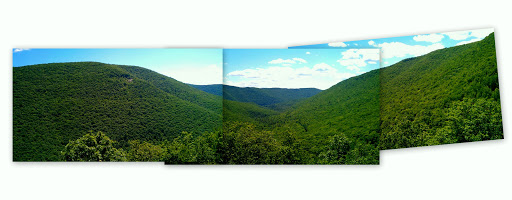 |
| As best I can tell, these are the only three photos I took on the “knife’s edge,” BFT Day 2. In these, you’re looking southeast into Slate Run. On the left at the top of the mountain is an old quarry. |
Unfortunately, we didn’t take many photos either, partly because the ground was rough and by that point, Josh and I were experiencing enough knee pain that we knew one wrong footing had the potential to send us off a small cliff.
But nothing could replace the mental imagery that will live with me for the rest of my life. And I guess that’s the entire point of going into wild and semi-wild places. As much as I love sharing these with all of you, I do it for myself. I don’t want to get to my death bed and say, “I wish I had…”
Disaster strikes
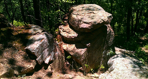 |
| Rock scramble on the descent from the “knife edge.” |
After the knife’s edge, the BFT descends sharply to Slate Run Road, at points offering short downhill scrambles through rock ledges, or down 50 feet in a mere 20 feet of distance. Josh was moving faster down hill, but I could tell even he was slowing considerably.
Crossing Slate Run Road, we started walking along relatively level ground along Slate Run, but on every uphill Josh slowed to a crawl and I could tell he was in pain as he limped heavily leaning on his walking stick. And he started talking about the trail ahead, with particular focus on the tremendous ascent on the other side of the run to the plateau rim.
“Shit, I don’t think I can go any farther,” he suddenly said. “I’m sorry, man. Another uphill is going to kill me.”
“What’s wrong?” I asked.
“It’s my left knee, in the back. There’s this sharp pain tearing through it in the middle, just from walking on flat ground.”
Immediately, my thought was an ACL injury. “Well, let’s rest, eat something, and look at the map to assess our situation. We’re not far from mile zero anyway.”
Josh put a chemical ice pack on the back of his knee and we ate a very late lunch. It was already after 1:30 and we were making very poor time if we wanted to make it up the mountain and to the next camp at mile 12. As I looked at the map, it became apparent that climbing more than 1,200 feet could reasonably leave Josh lame and me to drag his sorry ass down the mountain. And then we’d still be more than 20 miles from our car with one of us unable to walk.
Part of me wanted to tell him to suck it up, but that’s a hard thing to say to a friend you know has already been through the trials of Army boot camp. Come on, you pansy. My grandmother could walk 12 miles with two bum knees!
No, this trip was done. I had to admit it. But as Josh winced in pain, just from shifting his weight while sitting, the only thing I could think was: FUCK! THIS TRAIL FUCKED US AGAIN!
Camp 2
We bagged the trek. It was the only thing we could do. Even though I knew my knees would hold out, Josh’s likely wouldn’t. We slogged the last mile or so limping into the camp site at a bend in Slate Run below a rock ledge at mile zero, dropped our packs and started considering the best place to hang the hammocks.
It was officially decided. The trek was over… sort of. We still had to find a way to get from Slate Run back up the mountain to our car… more than 20 miles away.
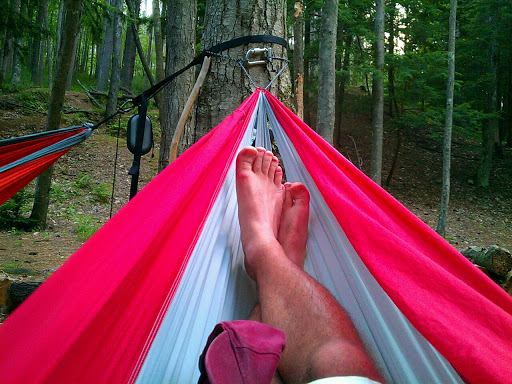 |
| Quality rigging of the hammock at camp 2. |
Soon a couple of parties of people walked into camp. They were locals who’d come to drink beer and swim in the natural pools forming at the creek bend. We made small talk, but we were drained and soon crashed into our hammocks for a two-hour nap.
One of my proudest moments came at camp 2. We found good trees with proper spacing for the hammocks, the tree Josh and I shared on the one side was too big for my hammock ropes. I quickly improvised a solution using my sole climbing carabiner. It was so good, I’m meaning to do a short video to show others. Forthcoming…
When we woke, a mother was swimming with her children in the creek but the beer party had gone. We spent the remainder of the day taking photographs around camp and squaring it away for the night.
Collect the fire wood. Get water. Attempt to purify water with a UV Steri-pen that was out of batteries. Play music on Josh’s iPhone. Rearrange the camp fire ring so it wasn’t too close to the hammocks. Snack on beef jerky and Clif bars.
 |
| A giant snail explores a log. |
We did see some more wildlife at Camp 2. As we were moving rocks on the fire ring, we found some land snails. And another surprise. Josh turned over a rock and bright orange sent us both flying back from the rocks. The primal part of our brains screamed COPPERHEAD! But in reality it was just a bright orange long-tailed salamander. We felt silly for jumping back, but I guess when you’re turning over rocks in the mountains, it doesn’t hurt to be careful.
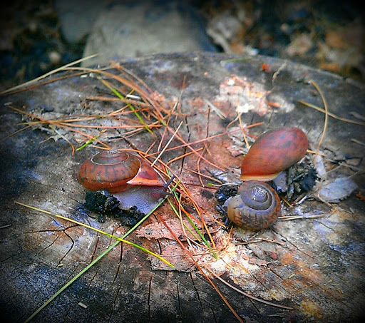 |
| Land snails saved from the fire ring. |
Seeing wildlife on the trail is a great experience. In 2001, backpacking with my brother-in-law on Chuck Keiper Trail, we heard a bobcat growl at us in the dark as we tried to find the trail head. We decided to crawl into our sleeping bags, light a fire and find the trail in the morning.
One afternoon descending into a wildness area, we saw a porcupine lumbering along the trail in front of us. The next morning, as I exited the tent to stretch, a large gray fox slipped along the creek about 50 yards from our camp, inspecting us with cautious interest.
But I’m just as enthusiastic about seeing the small animals that can go unnoticed. Snails, salamanders, frogs, toads, snakes, grouse and fat little field mice are as important to the ecology of our planet as are the larger mammals.
Next in “Third time’s a charm”: Well deserved rest, into Slate Run and the reluctant “Good Samaritans.”
