By Jim T. Ryan, Hooligan-in-Chief
Previously: In Part 1, Josh Stadler and I set out to conquer the 42-mile Black Forest Trail in Tiadaghton State Forest, Pa., only to be confronted with the need to retrieve our map from the car after less than 3 miles.
 |
| Josh cuts a walking stick. |
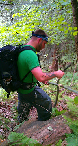
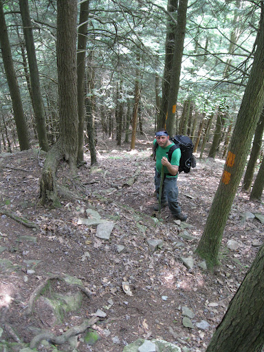
I have to give Josh a lot of credit for his performance on the BFT that first day. Despite being sick and hungover, he blazed the trail with pace and determination and on a few stretches, I actually found myself losing him around a turn as we practically jogged our first miles.
But backtracking to the car for the maps really drained us of that initial gusto. For starters, we jogged the trail back to the last dirt road we crossed. Then we followed it back to the car. We made good time, but it was still a backtrack.
I could feel the gravel of the road with full knowledge it would come back to haunt me. It was like stone penetrated my boots, then my feet, travelling up my legs to my knees where ever sharp corner tore at my tendons and ligaments. The pain wasn’t immediate, but I knew later I would feel it.
Cut Off Trail
Even before we reached the car, we had determined that there was no need to backtrack once again to continue our hike from where we left off. We did remember from our previous night’s map review, there was a trail that went from the dirt road branch back to the BFT at the western base of Hemlock Mountain. Then it was just a short climb to the ridge before descending into a creek run for lunch.
Retrieving the maps, we headed back toward the Cut Off Trail and found it’s gated entrance off the left fork of Trout Run Road, at that point known as Big Trail Road. We had to descend a couple hundred feet into the crotch between the main Allegheny Plateau and Hemlock Mtn.
 |
| Laurel in full bloom |
 |
| Mushroom bells sprout from the leaves on Hemlock’s saddle. |
 |
| Strangalia luteicornis, a flower longhorn beetle, on a pasture rose. |
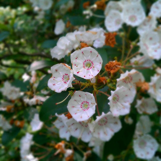
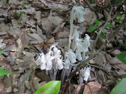
Eight-foot-tall laurels dotted the trail and flowers poked out here and there. Birds rustled in the underbrush. Mushrooms poked through the forest’s leafy floor. Butterflies fluttered around, moving from humid pollen cloud to pollen cloud.
Periodically, in the distance we would see a pink flower sprouting from a short bush, but with none next to the trail, we kept walking until curiosity got the better of us. Venturing about 30 feet off trail we found the flower — a pasture rose — and a rather remarkable insect. I’d never seen them before and neither had Josh. Turns out we had found a type of flower longhorn beetle, a common beetle to most of the eastern U.S., but one that has many variations. The variation we found is strangalia luteicornis, which has a more slender body than its cousins.
I find insects to be fascinating creatures. They outnumber us by the trillions. They’ve outlived everything other than bacteria on this planet. And their variety is incredibly complex.
Mountains, waterfalls and camp
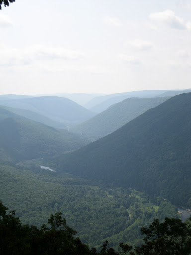
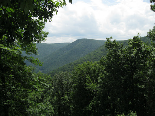
Towering above the Pine Creek Gorge at 2,080 feet, Hemlock Mtn. is one of the few “true” mountains along the lower Pennsylvania Grand Canyon. It’s a true mountain in the sense that erosion has cut a clear divide between it and the rest of the main Allegheny Plateau. Other mountains in the area are either knobs on the plateau or simply intriguing fingers of the plateau that resemble mountains elsewhere, yet lack that divide.
After crossing the saddle, BFT rises slowly to the west base of Hemlock Mtn. And then there it is, a rather rugged climb (upper moderate, non-technical) up the west face for about 100 feet in elevation over the span of maybe half the distance horizontally.
 |
| Pine Creek Gorge looking south from Hemlock Mtn. |
But once on top, Hemlock offers some stunning views of the lower gorge looking north and south, giving you a sense of scale for water’s raw power to cut through millions of years of rock in a short time. The canyon is estimated to be about 20,000 years old, primarily formed through glacial melt erosion at the end of the last ice age.
 |
| Haze hangs around the gorge’s meandering creek. |
We sat at each of the overlooks, lingering for photo after photo, almost paralyzed by the the vistas as if stuck to the mountain with magnetic electricity. Moving on was almost impossible, but if you’re trying to conquer 42 miles in three days, you also need to make serious tracks on at least two of those days, and we were BEHIND schedule!
So onward, and downward. Few people would look at a 42-mile trail in Pennsylvania and think, That’s one of the toughest hikes anywhere. But that’s what the BFT is, one of the toughest hikes anywhere. From mile marker 24 to the trail’s terminus in Slate Run, BFT has no fewer than 11 ascents and descents. Half of those you’re climbing or descending about 1,000 feet in less than a mile.
In case I didn’t already mention it, my knees take a pounding on rough trail, particularly on the downhills. The descent from Hemlock Mtn. cut into me early. It’s one of the more intense downhills along the BFT. Starting at the top of the mountain, you lose more than 1,100 feet of altitude in a mile to Naval Run. The rocky slope through a Hemlock forest is home to an abundance of frogs and toads who bask in the moist soils and intermittent sunshine through the thick canopy of needled boughs. The BFT switchbacks down the mountain to reduce the strain of a straight descent, but switchbacks are nearly as hard on the body because they add distance and lengthen the amount of time on the steep slopes of a mountain.
 |
| Josh pauses on the downslope of Hemlock Mtn. |
But I’ll take the switchbacks over a straight descent on the BFT, any day. Learned that lesson the hard way last January when we abandoned the trail and walked down a mile-long 1,100-foot slope. It was a necessary side adventure at the time, but man did it hurt and nothing felt as good as getting to flat ground next to a stream where we could build a fire and sit down.
Hemlock Mtn. ends at Naval Run in Jerald Hollow, named for one of the first foresters to work in this part of Pennsylvania. In 1914, Frank Jerald was mistakenly shot by a hunter in this hollow alongside the run, according to Chuck Dillon’s 2008 BFT guidebook.
We found a campsite and stopped for lunch, unknowingly just above two waterfalls. The first trickled between two ledges down to a pool.
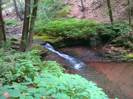 |
| A waterfall and pool on Naval Run, mile 31. |
Return to ‘Pirate Mountain’
Remember that 1,100-foot non-trail descent we did in January? Yeah, we dubbed that finger of the Allegheny Plateau to be “Pirate Mountain.” After lunch, Josh and I started up the three-mile long climb from the 900-foot hollow to the top of the 2,100-foot Pirate’s finger (as in middle finger).
In the summer, the tree blow-downs allow the day’s scorching heat to pound the BFT and any soul on it. Josh succumbed first, stripping off his shirt and having to stop to drench his head in water to fend off heat exhaustion. Soon, I too stripped off my shirt.
More switchbacks. And then the long slog up a straight uphill.
 |
| Half Dome, highest direct rise from creek to rim, day 1. |
At several spots along this part of the trail, you get the best views of “Half Dome,” a quasi-mountain along Pine Creek Gorge that — at certain angles — resembles Half Dome in Yosemite Valley. Albeit, Pennsylvania’s “Half Dome” is forested and carved by erosion, rather than granite uplifting and glacial carving as is the case in Yosemite. Still, it’s a pretty cool site and Pine Creek’s Half Dome is the highest direct rise from the creek to the plateau rim with a relief of 1,360 feet and an elevation of 2,060 feet.
Pirate Mtn. also gives you some of your first looks into the northern bends of Pine Creek Gorge, offering a glimpse of the days ahead of you and spectacular views of the undulating ribbon of water that’s carved it. As we hopped from vista to vista, there was one thing on my mind: on the downside of Pirate Mtn. is a switchbacking part of the trail that we came up in winter and at some points was a rock scramble. With my knees, starting to feel the gravel from earlier, I wondered how well I’d do.
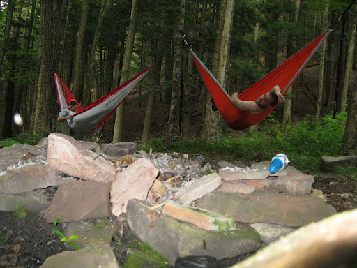 |
| Josh and I relax in the hammocks. |
Before I knew it though, Josh and I were descending into camp at mile 36 along Little Slate Run. We could’ve done another couple miles uphill to the next camp with the daylight we had. However, Josh was tiring on the uphills and my knees couldn’t take another downhill of any sort. Let’s remember, we did just recover (slightly) from nearly no sleep and too much beer.
So we set up camp. For me, it was a chance to try out my new Byer hammock. It also was a chance to unload our packs of a few pounds of food, namely two large steaks, bread and other snacks.
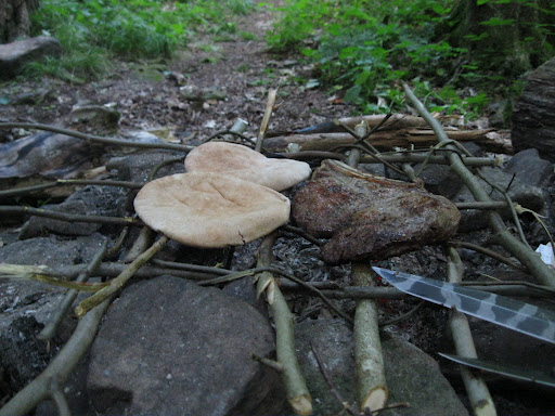 |
| Flat bread and steaks over the fire. |
And even if you’re camping in northern Pa. in the summer, remember a ski cap for night time. Because although the sun may be scorching you at 90 degrees (F) in mid-day, the temperatures in the hollows can drop down to the 50s.
Cold or not, nothing is better on the trail than a roaring fire and that first night’s meal. I’d walk forever if I knew those two things would be at the end.
 |
| Relaxing around the campfire, end of day 1. |
